
In an attempt to trace the history of Siam Garden in Gaol Lane on behalf of the residents whose houses overlook the site, I was given the opportunity to look at an ancient document concerning Siam Place. Although it gave no clue to the garden’s origin it did contain a valuable piece of information which enabled me to identify the exact location of a ‘lost’ 14th century Manor called Place’s presumably after the family who first owned it.
A description of the Manor as it was in 1604 and details of its ownership are given in a pamphlet published by Alan W. Berry (now out of print) a Freeman of Sudbury and an historian. Following that description and using the information from the Siam Place deed and a large scale Ordnance Survey map C.1890 I was able to identify the site of Place’s Croft.
Place’s Croft occupied the site of Siam Place (in yellow below), The Dentist’s Surgery (once a silk factory) and that part of North Street Car Park occupying the site of Gooseberry Row, or Garden Row, which was its correct name. The boundary of the croft on which these places stood is clearly shown on the map and the dimensions, after checking, agree with the details of 1604.
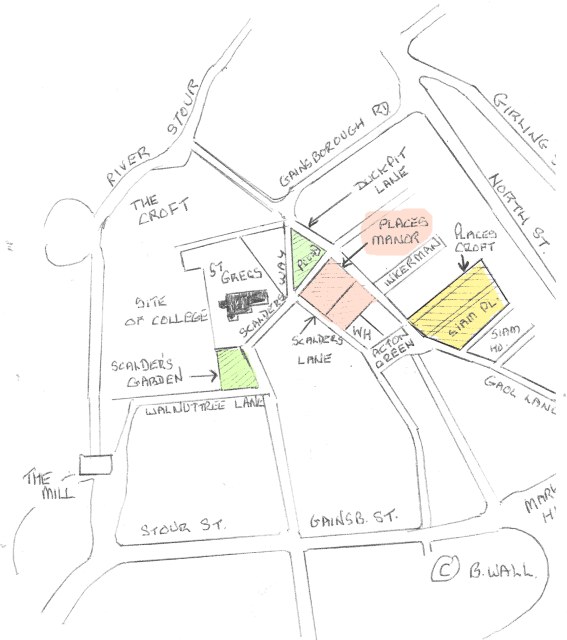
Having located Place’s Croft (in yellow above), I now had to fmd a piece of land used as a cattle pound described in 1604 as The Triangle and situated between Duckpit Lane to the east arid Scalder’s Way to the west. Duckpit Lane ran from Acton Green to the river where the Ducking Stool was placed. I had already identified Scalder’s Way while researching another property as the road, which bisects the Croft on the one-way system. The Triangle is still there and forms the South Side of The Croft.
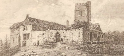
Manor House, Yard and Orchard
This was paled and enclosed in 1604. Adjoining the Triangle and lying between Duckpit Lane (Croft Road) and Scalder’s Lane (Church Walk) Occupying one rood more or less. The Social Club and the houses fronting The Croft from there to Church Walk now occupy this area.
Little Orchard
This is described as being immediately south of the above with a gate leading into Duckpit Lane and measuring 16 Perches. This was the site of the Old Poultry and Egg Market and is now the site of the new flats adjoining The Wagon and Horses.
The Manor owned a separate parcel of land outside the town called Moon Hall, which is now the Town Cemetery.
The origins of the Manor are obscure and the earliest references are Court Fines dating from after the Reformation in 1547, 1549 and 1550. The fact that part is sited inside the Great Ditch with Place’s Croft outside, suggests that this was a manor created when the town was expanded by Elizabeth De Burgh around 1327-1340 when the Ditch was filled in.
The only family I can trace with the name of Place was John Place of Lavenham, a very wealthy Cloth Merchant, but his will of 1440 has no mention of property in Sudbury.
In the 17th century the Daniels of Acton Place owned it. After that various parts were disposed of mainly to the Andrews brothers who acquired Simon’s College. Interestingly the Manor was held on a one thousand year lease and according to Mr. Berry’s pamphlet the principal interest in the residue of the lease was acquired by Robert Andrews in 1717. He was the father of Robert Andrews painted by Gainsborough in 1748.
Scalders Lane and Scalders Way
The piece of land between Church Walk and Gregory Street and facing The Croft was the site of the house and yard of William Scalder in the 1450s. His son John Scalder was a wealthy cloth merchant and Mayor of Sudbury in 1512-13. The group of houses outside the gate of St. Gregory’s’ stand on the site of Scalders Garden (in green above) which was purchased by the Eden family who lived at the Priory and Ballingdon Hall.
All of this gives a fascinating insight on the Croft area of Sudbury before it was all swept away to make room for the 18th and 19th century Weaver’s houses, which in turn have given way for a traffic system.
New Information
A Quitclaim dated 6 December 1345, from Simon Theobald to his parents Nigel and Sarah his wife of all lands and tenements which he had by gift from his father in Sudbury and Melford, has as a witness Johanne de Place.
Westminster Abbey Muniments 20866
Another document concerning the transfer of land from Nigel Theobald at Holgate in Sudbury to St. Bartholomew’s Priory names Robert ate Place as playing an important role in the transfer. 13 July 1357.
Westminster Abbey Muniments 20872
So Place’s Manor was situated less than 200 yards from the Theobald’s house by St. Gregory’s Church. This therefore goes some way to confirm a 14th century date for the creation of the Manor.
© Barry Wall 2008